
Tree inventory and analysis
Use geospatial intelligence for tree-by-tree analysis, enabling precise inventory management, growth-anomaly detection, and optimized input use across every sector of your estate.
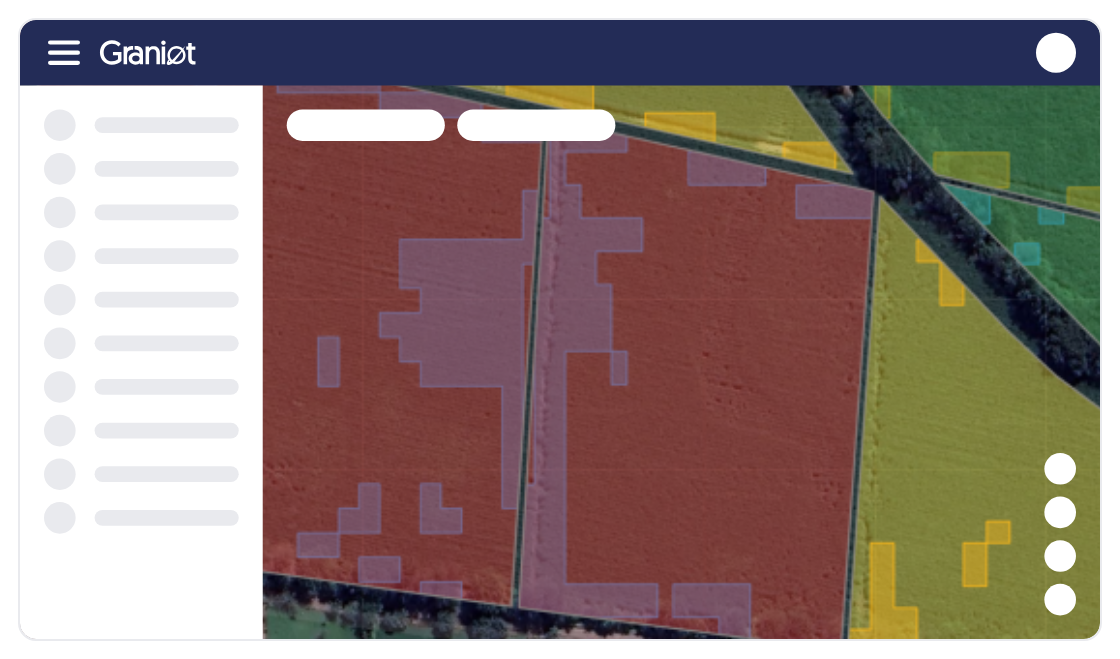
Avoid losses and reduce uncertainty. Our satellite monitoring system gives you a clear, up-to-date view of every parcel, letting you act early and secure the success of your harvest.
Identify areas of water stress, pests, or disease. Our AI tells you where and when to act to minimize yield loss.
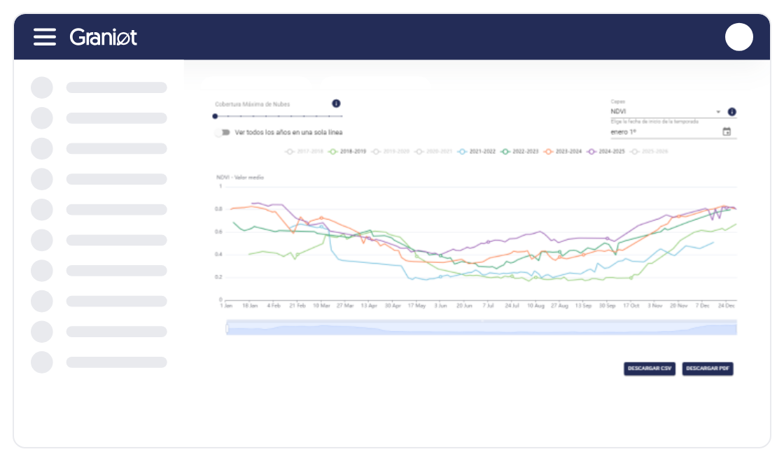
Access the satellite archive of your fields from 2017 to today. Compare performance across crop cycles to validate agronomic practices and long-term investment decisions.
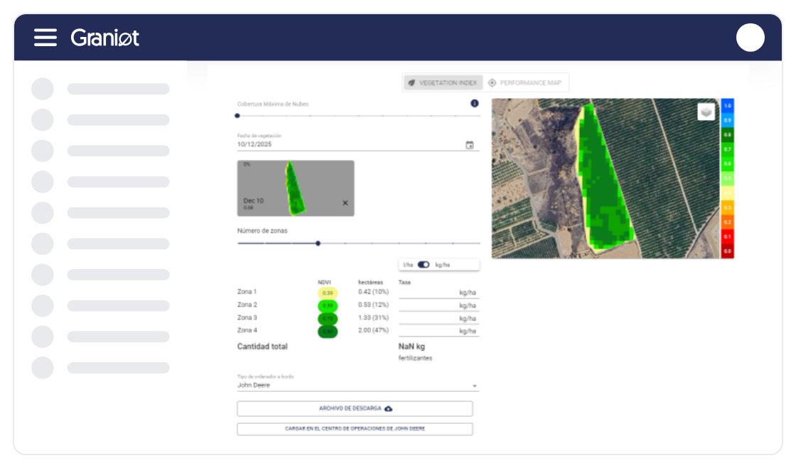
Generate variable-rate application (VRA) maps for fertilizer and water. Divide your fields automatically by yield potential.
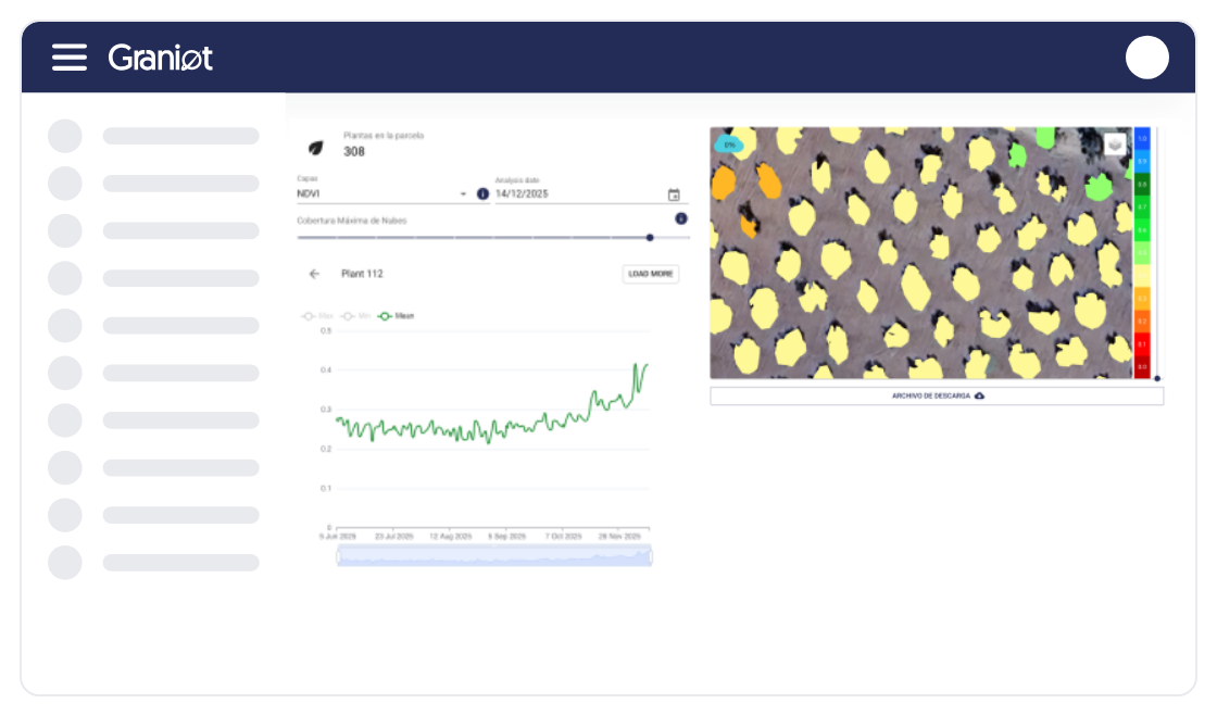
Analyze the vegetative state of each plant across satellite resolutions, enabling ultra-precise, localized crop management.
Flexibility is key. Discover how our technology adapts to your needs — through our platform, API integration, or embedded maps.
Access imagery up to 30x30 cm for detailed analysis.
Use our image comparator to analyze the state of your estate before and after treatment.
Check hourly forecasts and critical AEMET data to decide the exact moment of application.
Create geo-referenced notes, attach photos and documents, and simplify field-team communication.
Integrate our seeding and variable-rate fertilization maps directly into your tractor — no additional hardware required.
Reliable data. Less risk. Our satellite technology is the foundation for reducing losses, maximizing ROI per parcel, and securing the profitability of your agricultural business.


I see the real condition of every tree and apply inputs only where my crop actually needs them.

I process thousands of parcels in a single submission and get the results without operational bottlenecks.

Now I have the exact inventory of my trees and real control over what's happening on my estate.
I have all my parcels organized on the platform and it saves me a lot of time every day.

Graniot's embedded maps let us easily incorporate satellite technology into Dataris.
Send us your questions or requirements. Our team of experts will contact you to design a tailored solution that boosts your operational efficiency.
Use geospatial intelligence for tree-by-tree analysis, enabling precise inventory management, growth-anomaly detection, and optimized input use across every sector of your estate.

Ensure full traceability of your supply chain with non-deforestation reports generated at scale, guaranteeing that every parcel meets European standards for export without legal risk.

Monitor construction progress and pavement condition remotely, using satellite data to prioritize preventive maintenance and drastically reduce technical inspection costs.
How accurate is Graniot's satellite data?
We use very-high-resolution satellites that detect vegetation variations down to 30 cm. This ensures anomalies, water stress, and pests are located with the precision needed for effective, targeted intervention — avoiding losses in healthy areas.
Do I need additional hardware in my field to use the platform?
No. Our Crop Monitoring service operates 100% with satellite technology and cloud processing. It requires no sensors, weather stations, or any additional hardware on your parcels. You only need internet access to use our platform or integrate the data via API.
Can I integrate Crop Monitoring data with my existing management software?
Yes. We offer a robust API (Application Programming Interface) that enables seamless, automated integration of all indices, alerts, and parcel histories directly with your existing agricultural management systems, ERP, or variable-rate application software.
How are water and fertilizer savings measured?
Our platform uses vigor indices (like NDVI) and water-stress indices to generate zoning maps. These maps tell you exactly which areas of your field need more or less inputs, letting you dose and apply only where needed. Savings are calculated by comparing typical consumption with the optimized usage the platform recommends.